Sunday, December 22, 2024
Latest:

ការធ្វើឱ្យប្រសើរឡើងវិញនូវប្រព័ន្ធធារាសាស្រ្តសម័យបុរាណ Restoration of Angkor Hydraulic Network

Share Post:

ការធ្វើឱ្យប្រសើរឡើងវិញនូវប្រព័ន្ធធារាសាស្រ្តសម័យបុរាណ

ការស្តារឱ្យប្រសើរឡើងវិញនូវប្រព័ន្ធធារាសាស្រ្តសម័យបុរាណ គឺជាការងារប្រឈមដ៏ចម្បងមួយក្នុងចំណោមការងារប្រឈមដទៃទៀតក្នុងរមណីយដ្ឋានអង្គរ។ កិច្ចការនេះមិនត្រឹមតែជាកង្វល់សម្រាប់ការអភិរក្សប្រាង្គប្រាសាទ និងការអភិវឌ្ឍប្រកបដោយចីរភាពនៃរមណីយដ្ឋានអង្គរប៉ុណ្ណោះទេ តែក៏ជាបញ្ហាប្រឈមក្នុងការរក្សាតុល្យភាពទឹកនៅក្នុងតំបន់សៀមរាបទាំងមូល ព្រោះកំណើនដ៏ឆាប់រហ័សនៃចំនួនភ្ញៀវទេសចរ និងប្រជាជន។ ដំណោះស្រាយគន្លឹះជាចាំបាច់ក្នុងការឆ្លើយតបតម្រូវការក្នុងការប្រើប្រាស់ទឹកប្រចាំថ្ងៃ និងការធានាឱ្យមានស្ថិរភាពចំពោះប្រាង្គប្រាសាទ ដែលសាងសង់នៅលើគ្រឹះខ្សាច់ គឺពង្រីកលទ្ធភាពរក្សាទឹកនៅតាមទីតាំងរក្សាទុកសំខាន់ៗក្នុងរមណីយដ្ឋានអង្គ។

ដើម្បីអនុវត្តនូវផែនការពង្រីកលទ្ធភាពរក្សាទឹកឱ្យបានកម្រិតខ្ពស់បំផុត ដែលអាចទៅបានអាជ្ញាធរជាតិអប្សរាបានវិភាគតាមបែបវិទ្យាសាស្ត្រអំពីប្រភពដើម ដែលចេញពីអាងផ្ទៃរងទឹកភ្លៀងនៅលើភ្នំគូលែនរហូតដល់កន្លែង ដែលទឹកហូរចាក់ទៅក្នុងបឹងទន្លេសាប។ ពុំមានសិលាចារឹកណាមួយនាសម័យអាណាចក្រខ្មែរ បានលើកឡើងពាក់ព័ន្ធនឹងបញ្ហាទឹកជំនន់ឬភាពរាំងស្ងួតឡើយ ហើយប្រជាជនខ្មែរក៏មិនបាននិទានតគ្នាតាមរយៈរឿងព្រេងឬការចងចាំពីជំនាន់មួយទៅជំនាន់មួយអំពីគ្រោះធម្មជាតិណាមួយនោះដែរ។ តាមរយៈនេះ គេអាចសន្និដ្ឋានថា បញ្ហាទាំងនេះពុំមានកើតឡើងទេនាសម័យអតីតកាល ព្រោះប្រព័ន្ធគ្រប់គ្រងធារាសាស្រ្តសម័យបុរាណ  មានលទ្ធភាពគ្រប់គ្រងទឹកបានយ៉ាងល្អប្រសើរបំផុត។ ការសន្និដ្ឋាននេះគឺចាប់ផ្តើមពីការពិនិត្យតាមបែបធម្មជាតិ និងវិទ្យាសាស្ត្រនៃលំហូរទឹក និងបណ្តាញតភ្ជាប់គ្នាជាទូទៅ រវាងប្រព័ន្ធធារាសាស្រ្តក្នុងរមណីយដ្ឋានអង្គរ រួមមានផ្លូវទឹកហូរតាមស្ទឹងពួកនៅផ្នែកខាងលិច ស្ទឹងសៀមរាបនៅផ្នែកកណ្តាល និងស្ទឹងរលួសនៅផ្នែកខាងកើតបារាយណ៍ កសិន្ទុទឹក អូរ អាងទឹក និងប្រឡាយទឹកតូចធំខ្វាត់ខ្វែងផ្សេងៗ។ តាមការពិនិត្យច្បាស់លាស់ ស្ទឹងពួក និងស្ទឹងរលួសគឺជាស្ទឹងដែលកើតមានតាមលក្ខណៈធម្មជាតិ ចំណែកឯស្ទឹងសៀមរាបវិញហាក់ដូចជាផ្លូវទឹកសិប្បនិមិត្ត ព្រោះស្ទឹងនេះត្រូវបានបង្កើតឡើងដើម្បីពង្វាងទឹកពីភ្នំគូលែនដោយមានការសាងសង់សំណង់បង្អៀរទឹកអំពីថ្មបាយក្រៀមនៅសតវត្សទី៩ នៅភូមិបំពេញរាជ ដែលមានទទឹង៦០ ម៉ែត្រ និងបណ្តោយ៣០០ ម៉ែត្រ។

ក្នុងជំហានបន្ទាប់ អាជ្ញាធរជាតិអប្សរាបានចំណាយពេលសិក្សាស្រាវជ្រាវជាក់ស្តែងអំពីប្រព័ន្ធធារាសាស្ត្របុរាណ
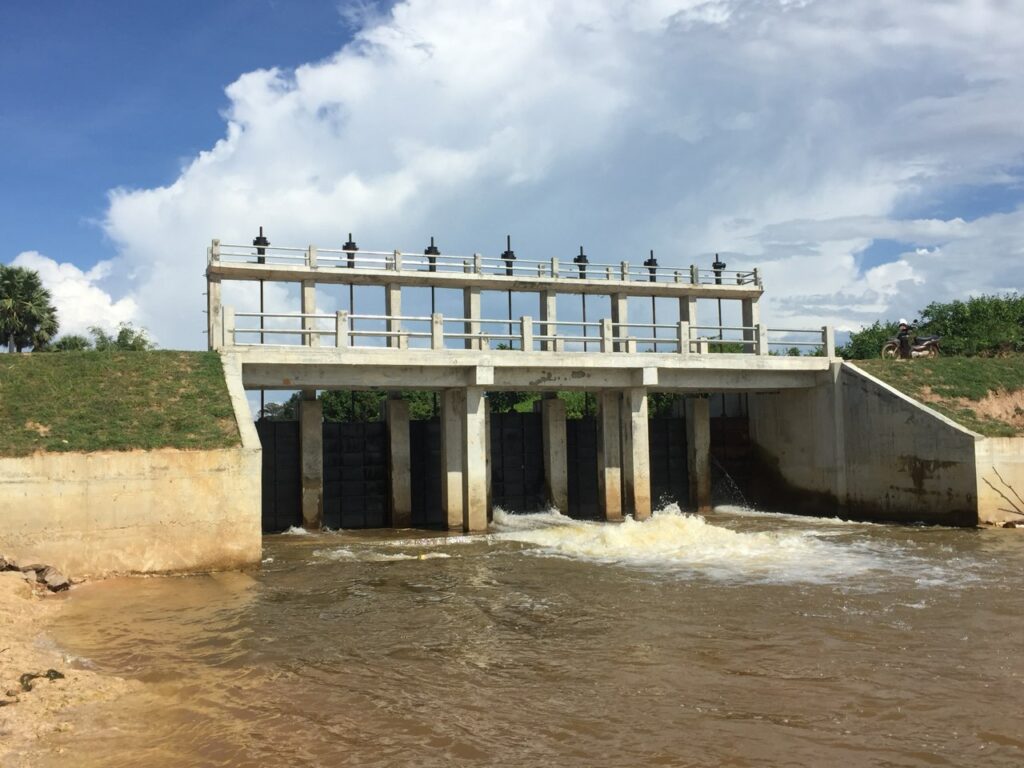
រយៈពេល៨ឆ្នាំ។ ក្នុងរយៈពេលនៃការសិក្សាបានបង្ហាញថា ផ្នែកខាងជើងឆៀងខាងកើតនៃបារាយណ៍ខាងជើងមានទំនប់មួយដែលគេសង់ក្នុង ទិសពីកើតទៅលិច និងមានស្ពានបុរាណមួយធ្វើពីថ្មបាយក្រៀម ដែលមានប្រឡោះបង្ហូរទឹកជាច្រើនសង់លើស្ទឹងសៀមរាប អាចត្រូវបានប្រើប្រាស់សម្រាប់លំហូរទឹក និងគ្រប់គ្រងទ្វារទឹក។ ដោយសារប្រព័ន្ធចែកចាយ និងអូរប្រទាក់ក្រឡាគ្នាជាច្រើននេះហើយ ទើបការបង្វែរទឹកទៅទិសខាងលិច (បារាយណ៍ខាងជើង បារាយណ៍ខាងលិច និងស្ទឹង ពួក) ទៅទិសខាងកើត (ស្ទឹងរលួស) និងទិសខាងត្បូង (កសិន្ទុទឹកទីក្រុងអង្គរធំ កសិន្ទុទឹកប្រាសាទអង្គរវត្ត និងស្ទឹងសៀមរាប) អាចធ្វើឡើងបានដោយរលូនពុំមានឧបសគ្គអ្វីទាំងអស់។

ឆ្លងកាត់ការវិភាគទិន្នន័យដំបូង និងការសន្និដ្ឋានវិទ្យាសាស្ត្រនៃទឹកជំនន់ឆ្នាំ២០០៩ ឆ្នាំ២០១០ និងឆ្នាំ២០១១ អាជ្ញាធរជាតិអប្សរា បានអនុវត្តនូវការងារជាក់ស្តែងចាំបាច់មួយចំនួនដូចជា ការជួសជុល និងស្តារប្រព័ន្ធធារាសាស្ត្របុរាណសម័យអង្គរឱ្យដំណើរការឡើងវិញជាស្ថាពរ។ ជាពិសេសនៅឆ្នាំ២០១២ ផ្នែកដ៏សំខាន់នៃប្រព័ន្ធធារាសាស្ត្របុរាណសម័យអង្គរត្រូវបានស្ដារឡើងវិញ ដែលការស្តារនេះធ្វើ ឱ្យរមណីយដ្ឋានអង្គរ និងទីក្រុងសៀមរាបទាំងមូលបានជៀសផុតពីការរងគ្រោះទឹកជំនន់។ ចំណុចនេះបញ្ជាក់យ៉ាងច្បាស់ថា ប្រព័ន្ធធារាសាស្ត្របុរាណសម័យអង្គរ មិនត្រឹមតែអាចគ្រប់គ្រងនូវធនធានទឹកបានយ៉ាងល្អប៉ុណ្ណោះទេ តែថែមទាំងអាចគ្រប់គ្រងទឹកជំនន់បានទៀតផង។


Restoration of Angkor Hydraulic Network

Restoring ancient irrigation is one of the main challenges in the Angkor site. This is not only a concern for the conservation of the temples and the sustainable development of Angkor but also a challenge to maintain water balance in the entire Siem Reap area due to the rapid growth of the number of tourists and the population. The key solution needed to meet the needs of daily water use and to ensure the stability of temples built on sand foundations is to expand water storage capacity at key reservoirs in the Angkor site.

In order to implement the plan to expand water storage capacity to the highest level possible, the APSARA National Authority has scientifically analyzed the origin from the catchment basin on Kulen Mountain to the point where the water flows into Tonle Sap. None of the inscriptions of the Khmer Empire mention the issue of floods or droughts, and the Khmer people have not narrated through legends or memories from generation to generation about any natural disaster. From this, it can be concluded that these problems did not occur in the past because the ancient irrigation management system was able to control the water very well. This conclusion is based on a natural and scientific examination of the water flow and the general interconnection between the irrigation system in the Angkor site, including the waterways along the Puok River in the west, the Siem Reap River in the central part, and the Rolous River in the East of the baray, moats, streams, pools, and canals. On closer inspection, Puok River and Rolous River are naturally occurring rivers, while the Siem Reap River appears to be an artificial waterway as it was created to divert water from Phnom Kulen with a stone dike construction that was built in the 9th century in the Bompenh Reach village, which is 60 meters wide and 300 meters long.

In the next step, the APSARA National Authority spent eight years conducting practical research on the ancient irrigation system. The study period showed that the northeastern part of the northern baray had a dam built from east to west and an ancient stone bridge made of laterite with many drainage barriers built on Siem Reap River that can be used for water flow and control. Due to these interconnected systems and streams, the diversion of water to the west (northern baray, western baray, and Puok River) to the east (Rolous River) and south (Angkor Thom’s moat, Angkor Wat,’s moat, and Siem Reap River) can be done smoothly without any obstacles.

Through the analysis of preliminary data and scientific conclusions of the floods of 2009, 2010, and 2011, the APSARA National Authority has carried out a number of necessary practical tasks, such as repairing and restoring the ancient Angkor irrigation system. Especially in 2012, a significant part of the ancient Angkor irrigation system was restored, which prevented the Angkor site and the entire city of Siem Reap from being flooded. This clearly indicates that the ancient Angkor irrigation system not only managed the water resources well but also managed the floods.

Share:

Facebook
Twitter
Pinterest
LinkedIn